The OpenDRI team is super excited about UR2016 in Venice! As always, the schedule is jam packed full of interesting and innovative sessions that we can’t wait to participate in and learn from. The themes of open data, community participation in risk assessment, and improving risk communications are all hot topics at this event. We’re excited to see this ideas continue to gain traction in the Understanding Risk Community.
At this UR, we are releasing a new short video that gives an introduction and overview of the Open Data for Resilience Initiative:
We also are launching a brand new publication, the OpenDRI Policy Note and Principles, and co-organizing a number of sessions. Read on for details!
OpenDRI Policy Note & Principles
This publication is the result of long-term conversations within the team and our partners in organizations such as the Humanitarian OpenStreetMap Team, the US State Department, and the American Red Cross. It describes the approach taken by the OpenDRI team to design and enact impactful and sustainable projects with our partner organizations and communities. It is organized into a series of nine principles, the first 5 of which guide our thinking about how risk information should be created, managed, and used. The final 4 principles shape our relationships with other actors involved in OpenDRI work. Following a short description of each principle, we provide examples from past OpenDRI projects and suggestions for relevant resources. Download the new publication here: https://www.gfdrr.org/sites/default/files/publication/OpenDRI%20Policy%20Note.pdf
OpenDRI Focus Day Events and Technical Sessions
Tuesday
09:00 – 17:00 Learning InaSAFE through open data for resilience serious game! – GFDRR, Open Data for Resilience Initiative (OpenDRI), InaSAFE, DM Innovation, Australian Aid & Kartoza, Room: Sala A InaSAFE is a software tool intended to help disaster managers to be better prepared for natural disasters. It is a free software and runs on all major operating systems. InaSAFE has been used in many countries around the world. The workshop will be in two sessions: the morning session will be in the format of a ‘serious game’ where we will use InaSAFE and other tools to demonstrate the contingency planning process and show the effect that planning decisions can have on outcomes in the event of a disaster. During the afternoon session we will have a series of case studies where users of InaSAFE will share the achievements and pitfalls of using InaSAFE as a tool for disaster management. The afternoon session will conclude with an open forum discussion where users and prospective users of InaSAFE can voice their ideas, concerns and experiences. The workshop is open to users and prospective users of all skill and experience levels. You should bring your own laptop. We will supply all the software and training materials you need to get started with InaSAFE. These can be freely shared with your colleagues. If you wish to find out more about the InaSAFE project, please visit http://inasafe.org.
This side event will explore the risks to using certain types of data in the humanitarian and development spheres and in understanding risk. Discussion will focus on three areas:
1) Establishing a set of overarching principles for using data responsibly; 2) Methodologies and frameworks to determine the benefits and risks for using sensitive data; 3) Practical tools and mitigation strategies for managing sensitive data.
The event will include a keynote speaker with a question and answer session which will be followed by a workshop where participants can test their data against frameworks for assessing risk. The event will conclude with a summary of common data risks and harms and useful mitigation strategies.
Thursday
16:00 – 17:30 – Breaking barriers for the common good: Open data and shared risk analysis in support of multilateral action The quantity and quality of risk information for crisis and disaster prevention, preparedness and response is increasing. However, it is often sector-specific and not widely available to decision-makers and other stakeholders. Applying the concepts of open data can increase the quality and availability of information for managing crisis and disaster risk, and involve a broader section of the population in the challenge of building resilience. For it to be most effective, this information then needs to be translated into shared analysis that governments and their partners can use to work together to manage risks. Open and shared risk analysis can help overcome institutional barriers between governments, development, DRR, humanitarian and other multilateral actors. This session will look at advances in open data and shared risk analysis and envisage a future where they underpin collaborative and coordinated action between government, private sector, civil society, and the international community.
Friday
14:00 – 15:30 – Bridging the divide: Digital humanitarians and the Nepal earthquake When the Gorkha Earthquake struck in Nepal in April 2015, civil society groups from Nepal and around the world sought to provide aid to the affected and assistance to humanitarian responders working in the field. In recent years, “Digital Humanitarians,” who support disaster response by collecting, classifying, and analyzing critical information from social media and other sources have begun to play an increasingly important role during crises. Yet the extent to which formal responders in the Nepal government and international agencies and volunteer organizations like Kathmandu Living Labs, the Humanitarian OpenStreetMap Team, and the Digital Humanitarian Network collaborated during the Nepal Earthquake response was unprecedented. This session will examine the role that crowdsourcing and community mapping played in providing information to disaster responders in Nepal, explore the factors that facilitated partnership between the formal and the informal digital responders, and examine challenges experienced by the various actors. The session will also explore opportunities and barriers to undertaking similar efforts in other countries.
by Andrew Kruczkiewicz and Henry Karemeri Ndungu – Columbia University
In recent years an increase in temporal and spatial resolution of satellite observations has afforded new lenses of climate research. Initiatives have been established to explore the value of integrating these data into climate and weather research, increasing the understanding of modes of climate variability, microclimates and precipitation processes, amongst others. A persistent question however remains: with technological advancements in satellite engineering and subsequent gains in climate science, are gains in societal applications guaranteed?
Climate services are anything that involves the production, translation, transfer and use of Climate Knowledge and Information in climate-informed decision making and climate-smart policy and planning (GFCS). Arguably the most important element of the definition is the action. Without action, a climate service is simply data, practically useless, regardless of its format.
A multitude of climate services have been developed to aid in assessing climate and weather risk, but is it working? Are disaster managers better at understanding the probability of different types of floods or drought for instance, and further, able to act on that information? Would that acting upon that information reduce community risks to such hazards? Would such action contribute to learning and increase communities’ resilience?
While the end goal of action is consistent, the format of a climate service can be widely varied. Differences could include the interface, complexity of the data targeted end-user and, timeliness/availability, among many others.
Further, considering the subset of the humanitarian end-users, the diversity of decision making processes beg a tailored set of climate services. Building climate-resilient communities and minimizing (or averting) the impacts of a climate shock or weather-related disasters are examples of situations in which climate services may be used when planning for humanitarian interventions.
Many times lacking a background in climate science, humanitarian decision makers have questions regarding where to start when exploring the value of climate services. Would it be best to explore what has already been done in search of an analog decision-making process? Perhaps it is useful to review the many climate services that have already been developed first? Or alternatively, maybe beginning with a dataset that seems relevant, for example rainfall, and work forwards from there, identifying climate services using those data and thereafter evaluating impact.
Within the emerging space of climate services, many questions exist, most without a definitive answer. Exploring decisions and timescales is however considered
pertinent in terms of increasing the value of climate services, but the best way to do that is up for debate.
One of the recent application trends of climate services has been the utilization of open data, particularly in the context of historical climate and socioeconomic data. This data aids in understanding the interaction of the climate and society from a historical context, which in turn allows for patterns to be identified, enhancing forecasts.
While building new weather stations and acquiring data from them may increase understanding of weather, this data could never take the place of historical data, especially relative to an understanding of past climate conditions and extreme events, including droughts, floods and severe tropical cyclones, where other sources, such as cultural knowledge are of immense value.
Further, the opportunities presented by earth observations are plentiful. Continuously the amount of data derived from existing satellites and sensors increases. When these tested data are coupled with new, high-resolution products, the potential to infuse satellite technology within community level problem solving becomes more likely.
With an increase in climate and weather risks it is important to remember the end goal of taking action, of which a large part is identifying when and where to take action, across different timescales, and with utmost responsibility and accountability to those most in need of such services, and build their resilience. This session will delve deeper into the role of earth observations, open data and climate services in linking climate and weather data to action.
by Paolo Scussolini, PhD – VU University Amsterdam
Throughout history, our ancestors have lived together with water, and with floods. River banks, deltas and coasts have always been favoured for human settlements, and civilization has greatly benefited from proximity to water. People have long experience of overflowing waters, threatening their possessions, their crops, their cattle and their lives, and they therefore have devised ways to cope with this natural phenomenon.
People protect themselves and their interests with different approaches: they built their homes on higher ground and on stilts; they build levees and dikes to stave off waters; or use experience to avoid settling in areas prone to flooding.
Protection to flooding changes the risk that communities face, with higher protection standards generally meaning less risk of damages and fatalities. As reiterated in the Sendai Framework for Disaster Risk Reduction last year, the aim of the international community is to improve our understanding, and to quantify patterns of risk across the globe. This is important because it allows to identify the areas that suffer most, both now and in the future: the so-called risk-hotspots. With this knowledge, effective planning of risk-reducing actions can be carried out: building protection, building capacity and early warning and response systems, and in general, a more sound appraisal of the costs and benefits of investments in flood adaptation can be performed.
But understanding of flood risk, especially at large scales, is made difficult by the fact that for most places we simply do not know what the current standards of protection are.
For this reason, this side event the 2016 Understanding Risk Forum will bring together experts and practitioners from the flood risk community to exchange ideas and to improve the first global database of flood protection standards. This database, called FLOPROS (FLOod PROtection Standards), was recently set up by researchers in the Netherlands, at the Institute for Environmental Studies (IVM) and at Deltares, and collects information for all plausible sources in the literature, completing it with a modelling approach, to provide information on protection standards for most of the globe.
This work needs the contribution from the community of experts that operate especially in geographic areas where data are scarce, to compile information where it is presently still missing. Also, this information needs to be readily and freely available to risk-practitioners and researchers everywhere. For these two reasons, one of the aims of the side event is to coordinate the implementation of a website, where the database can both collect and provide information, from and to the large risk community.
Interested in learning more about the topics being discussed at UR2016? With a unique combination private sector businesses like FM Global, academic institutions like Columbia University, charities like BBC Media Action, policy makers, non-governmental organizations, and community-based organizations, this forum is not to be missed. See our featured bloggers below:
By Catalina Jaime, Red Cross Red Crescent Climate Centre
Forecast-based Financing (FbF) is a system to fill gaps in the humanitarian system by using the science of weather and climate to anticipate possible impacts in risk-prone areas and mobilize resources automatically before an event.
In FbF, humanitarian responders, meteorological services and communities agree on selected actions that are worth carrying out once a forecast reaches a certain threshold of probability. Each action is allocated a budget and funds are disbursed once the threshold is reached, according to predefined standard operational procedures.
This idea is now a reality. In a ground-breaking exercise in November 2015, the Uganda Red Cross (URC) activated a humanitarian action triggered by a scientific forecast of flood risk. Nearly 400 families were given 5,000 non-food items, including jerrycans and water-purification tablets. The forecasted region in Uganda is indeed now facing the impacts of floods. Rescue operations and emergency appeals have been activated. The communities reached by Forecast-based Financing are not included in the current emergency appeal that is seeking aid to the rest of the region.
The Uganda forecast was based on the European Commission’s Global Flood Awareness System and verified by the Uganda National Meteorological Agency, the Uganda Hydrological Department, and the European Centre for Medium Range Weather Forecasts.
“By using forecasts in this innovative project, we are now intervening even earlier, before receiving reports of disasters,” said URC Secretary General Robert Kwesiga. “With such timely disbursal, we hope to avoid catastrophe before it even happens, supporting people to continue working and going to school.”
The World Food Programme, meanwhile, in its own version of FbF, released funds in Guatemala and Zimbabwe through the Food Security Climate Resilience Facility in areas where drought risk was forecast to be great due to El Niño.
Other FbF pilot projects are now being implemented around the world aimed at improving cost-effectiveness. The Red Cross Red Crescent hopes to consolidate the best knowledge on climate science and disaster risk reduction and leverage it for the greatest humanitarian impact.
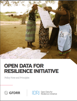 OpenDRI Policy Note & Principles